The name of Fincham is derived from the Saxon meaning either “The home of Finches” or “The settlement of Finn”. However, it is probable that this was not the first name given to this place as the majority of Romano-British place names have not survived. It is a village deep in layers of history that begin in the Neolithic period (4000 BC – 2300 BC) and evidence of settlement of some sort seems to be available from that time forwards. The position of the parish in an area of elevated well drained land that overlies chalk and flint bedrock has stimulated settlement from the very earliest of times. The parish is situated near the southern end of an area known as Norfolk’s western escarpment at an elevation of 20m above sea level.
There have been numerous archaeological finds within the parish and our knowledge of the deep history of Fincham will continue to grow as a full battery of new archaeological tools are brought to bear on its ancient ground. Detailed aerial imagery, LIDAR mapping, ground penetrating radar and advances in metal detection are revolutionising our capability and understanding of the long lost environment of our predecessors. Where excavations have been conducted at single locations they have revealed a rich spread of datable material that may extend all the way from the Iron Age to the medieval period. The official archaeological record continues to grow and at the time of writing (2020) the following represent just some of the evidence has been unearthed within the parish.
Neolithic (New Stone Age – 4000 BC – 2350 BC)
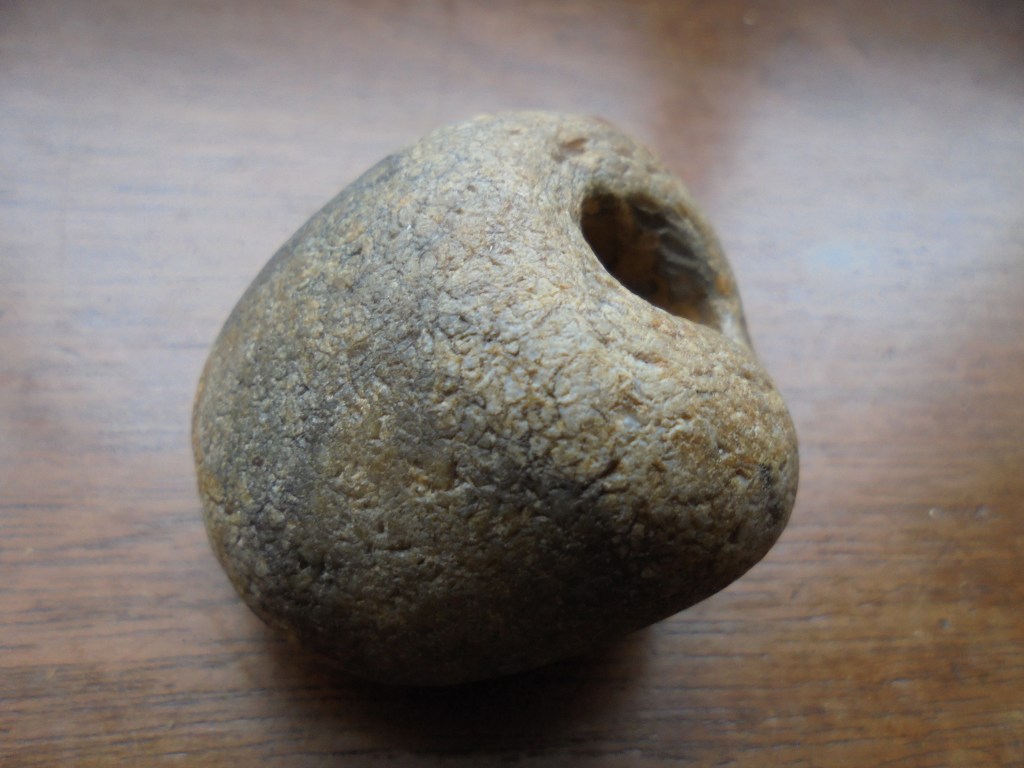
In an area rich in flint it is unsurprising that flint arrowheads have been found on field walks. Other finds include Prehistoric pottery and a polished axehead was discovered in 1953. There is no direct evidence of occupation of the parish, however traces of this era are often fleeting and difficult to establish.
Bronze Age (2351 BC – 701 BC)
In this period the first indications are apparent of perhaps seasonal settlement within the area. The building of earthworks requires organised and settled labour on a project that may take many months to complete. A Tumulus burial mound is located just over the western extremity of the parish boundary and its position may have served as a marker as land ownership became more closely defined during this period. In recent years aerial imagery has also indicated crop marks of four ring ditches.
This was also a period of climate change when the sea level rose inundating some of the east coast and widening tidal estuaries allowing greater penetration of the region by maritime craft from the fenland areas. The weather was warmer and dryer than today and this was favourable to agricultural improvement by the early settlers. Sea levels fell again later in this period.
Within the last 25 years there have been numerous finds to indicate human occupation during this period, Bronze Age metal work has been recovered by metal detectorists in locations throughout the parish. Finds include a late Bronze Age copper alloy sword and tools including socketed axe heads and awls. Three hoards of copper alloy objects have been found, including one of crushed copper alloy suggesting that it may have been for metal working, indeed the pattern of finds across the region suggests that the eastern edge of the fens saw a major concentration of population in this period.
The Iron Age (800 BC – 42 AD)
There is a mass of evidence to suggest a major occupation of the village during this period. Coinage was in limited use during the late Iron Age and it is rarely found in Norfolk, however this is not the case in Fincham. In 1994 and 1995 a hoard of silver coins was found by metal detectorists. The hoard included a rare coin of Presutagus, king of the Iceni and husband of Boudica. Another much large hoard of over 200 silver coins was found in 1998. A rich spread of artefacts, including brooches and terrets (parts of a horse harness) from this period has been found at various locations. On 28th February1860 a Gallo-Belgic gold coin on a chain was discovered in the roots of an old elm tree blown down in the rectory garden. Reverend William Blyth paid 12/- 6d for the ¼ Oz gold coin. This is just one of a number of gold coins that have been found scattered throughout the village.
Perhaps the most remarkable find has been the discovery of a pair of gold electrum (an alloy of Gold and Silver) Torc terminals found under floorboards in the attic of a house in late 1984. More Torcs have been found in East Anglia than in the rest of Britain and in Norfolk virtually all the Torcs have been found in the west of the county. West Norfolk was undoubtedly a centre of power and wealth during the Iron Age.
In the late Iron Age the character of the region changed again as the sea level rose to 1.5 metres above the level we know today. The inundation into the great fenland lasted between c. 250 BC and throughout the Roman period, thus the Roman invaders would have encountered a Norfolk that was bounded on its western border by a wide estuary with a coastline running approximately from Wisbech to Downham market. The rivers that fed into the estuary were also swollen and navigable to a deeper extent than we see today. Fincham lay on what would have been a peninsula of land between the River Wissey to the south and the River Nar to the north. The rivers would have given access to the North Sea and the lands beyond.
It is during this era that the Bicham Ditch or Devil’s Dyke was dug as a boundary marker on a north – south axis within the region to the east of the village. Although not passing through the parish, its construction demonstrates the power and organisation of the tribes at this time. Little is understood of the exact purpose and extent of this now almost invisible earthwork, but it is known to be a single bank and ditch 18 km in length running south from an iron age enclosure at Narborough Camp to a tributary of the River Wissey.
It is impossible to give an accurate impression of the village during this era but the large slew of finds to the north and east of the village would suggest that this may have been where the settlement has its origins. A collection of wattle and daub roundhouses may have first coalesced at an intersection of tracks that is now the Marham Hill crossroads. Water would have been drawn from wells as the water table in this area is not far below the surface. Agricultural activity would have included the keeping of sheep who were kept for their milk and wool rather than their meat. Weaving would have been a regular part of daily life. A loom weight was found in the author’s back garden a few years ago.
The Roman Occupation (43 AD to 409 AD)
Fincham was a staging point in the network of Roman roads that grew from the Roman occupation of Norfolk. By 70 AD a causeway crossed the Fens to the west of the region to approach the village of Denver just south of Downham Market. Denver was a centre of salt production at this time. It is believed that the causeway was then met by a Y junction that took roads east to the Roman towns of Caistor St Edmund and Brampton. Fincham lay along the route of the more northerly road to Brampton, indeed the A1122 though the village is still shown as a Roman road on Ordnance Survey maps. The impact of the road on the growth of the village has yet to be fully appreciated but there is certainly a great deal of evidence of Roman occupation of the parish.
In September 1801 a farm labourer ploughing a field turned up a Roman silver vase weighing 8 Ounces. The 20cm vase contained a small hoard of seven coins and it is believed to have been buried in the period between 395 AD and 400 AD. The vase was taken to Lynn and sold as old metal to a silversmith who then sold it to a Mr Hankinson. The vase was again sold at auction in 1941 and its whereabouts is now unknown. There have been a number of silver hoards found in the village and a broad scattering of Roman coins and metalwork has been unearthed throughout the area.
Excavations conducted by the Norfolk Archaeological Unit in 1992 revealed the site of a Roman building to the north of the village together with a rich spread of pottery, coins, brooches and building materials. Just over a mile to the west of the village there is clear evidence of a 1st century Roman Army marching camp at Barton Bendish, underlining the impact of the occupation in the immediate area. A marching camp is generally accepted to be temporary overnight resting place for a body of troops in transit across a region.
The Roman road through the village would have been a vital artery for the rapid deployment of troops following the Boudican revolt of 70 AD. The bloody suppression of the homeland of the Iceni would have been bourn heavily by a tribal population stripped of its young men who had either been slain in battle or taken as slaves by a punitive Roman Army. The position of the marching camp at Barton Bendish on the highest ground in the area would ensure that the Romans had a clear view of both the road and the surrounding region.
The Saxon Period (410 – 1065)
A profusion of finds confirms a steady growth in the size of the village during the Saxon period. It is probable that in the middle Saxon period (650 n- 850 AD) Fincham lay in the large Saxon manor of Wimbotsham. By the time of Edward the Confessor about 734 acres of land was under the plough and approximately 109 acres was in use as meadow, this would represent about a third of the total acreage of the parish as we know it today. There were 18 head of cattle 10 horses 500 sheep and 65 pigs. The land was tended by 71 Freemen and 2 Freewomen, 49 Boarderers, 23 Servi and 3 Villain. These figures suggest that sheep farming was already popular within the parish and a substantial revenue was being generated by landowners at this time. In 959 during the reign of Edgar, Downham was given to the Benedictine Abbey of Ramsay which became the chief landowner during this period. The comparatively high number of freemen and women is a feature of the west of the county at this time.
During the Early Saxon period (410 AD to 650 AD) the site of the Iron Age and Roman hoards and metalwork (Norfolk Heritage Explorer Record NHER 30049) was used as an inhumation cemetery, and a number of Early Saxon brooches and other personal items have been found on the site. A number of Early Saxon brooches (NHER 14530, 18849, 23911, 25737, 25857, 28227, 28228, 28238, 30056, 30059,30330, 33006, 34896 and 35594) have been found throughout the parish, as well as Early Saxon buckles (NHER 30057 and 33341) and an Early Saxon gold bracteate (NHER 33016).
By the Late Saxon period Fincham had grown into a large and wealthy parish, the Domesday Book records various land holders in the village, including a free woman named Aethelgyth. Late Saxon pottery , strap ends and coins have been found, including a short cross type penny (dated between 1029 and 1035) from the reign of King Cnut , and a cut halfpenny from the reign of Aethelred II (968-1016). Late Saxon pottery was found north of St Martin’s churchyard in 1985.
The Norman Period (1066 – 1154)
The Domesday Book of 1086 provides a remarkable insight into the economic effects of the restructuring of land ownership following the Norman invasion. The book provides a direct comparison between land and stock holdings in 1066 and those in 1086. Norfolk was a wealthy and populous place in the 11th century with Norwich second in size only to London and a greater density of habitation and plough teams than any other place in the country. The population of the county was approximately 150,000 (one sixth of the current population) at this time and this was parcelled into administrative and judicial divisions known as Hundreds.
There were 36 Domesday Hundreds of which the Hundred and a half of Clackclose, at more than 131 square miles, was one of the largest in Norfolk. Each Hundred was divided into“Leets” for the purposes of taxation and in the case of Clackclose there were ten Leets, although the extent and location of each of these divisions has now been lost to time. The rights and fines of the court Hundred were alienated from the crown to the Abbey of Ramsay that also held land in Fincham at this time. By 1272 the abbot of Ely had a baronial jurisdiction in Clackclose, with full judicial responsibility for taking out and return of all writs, view of frankpledge, forfeitures of felons’ goods and a prison and gallows at Wimbotsham. The court would meet for routine business every three weeks and for special session twice a year at Easter (March or April) or Michaelmas (September) at Clackclose Hill on Stradsett Common. The proximity of the Hundred court to Fincham may give some indication of the importance of the towne at the time.
In 1086 there were 35 settlements listed in the Hundred of Clackclose of which Fincham was by far the largest with a recorded population of 164 households, placing the village into the largest 20% of all settlements recorded in the Domesday Book. This number of households is on a par with the number recorded in the 1831 Census when the total population of the village was recorded at more than 750.
It seems probable that some expansion of the village settlement took place in the 11th and 12th centuries when Fincham experienced a phenomenon known as Common Edge Drift. This is a situation where population expansion from an essentially nucleated village overflows into land that is either less fertile or less well drained. The topography of the village shows a gradual 4m decline in elevation on the A1122 leading west out of the village onto what would have been the area known as the West Heath. In the 17th century no less than 27 buildings are shown in the common edge funnel leading to the village and whilst some of these structures would certainly have been barns and outbuildings, the distribution of small enclosed fields shows a echo of an even greater level of settlement that may have existed in earlier centuries. The 1772 Enclosure Act did much to destroy this common edge settlement on the south side of the Downham Road, whilst the recessed scattering of farms north of todays road such as Sun Dial and Daisey Farm indicate the true line of the original common edge settlement that existed on the north side of the common before enclosure.
The Norman invasion brought many changes as the Saxon gentry were supplanted by Norman overlords. The well established and comparatively wealthy village of Fincham had a new set of landlords thrust upon them. Approximately half of the cultivated land (375 acres) went to William de Warren, Count of Guarrenne in Normandy, who built a magnificent castle at the village of Acre, now called Castle Acre. As a powerful feudal landowner William de Warren held 139 lordships throughout the county on behalf of the king so his land at Fincham was sub-let to Hugh and William Brant.
The second largest proportion of the land was held by Hermer de Ferrers a powerful and violent Norman baron. He held 22 manors in Norfolk and 180 acres within the parish of Fincham. Not content with the land that had been granted him, Hermer seized other land within the county to the value of £20 19s 6d. In Fincham Hermer seized two Carucates of land (about 60 acres) formerly worked by 20 Freemen and a further 16 acres of land elsewhere in the village. The De Ferrers built and held the castle at Wormegay until 1166 and the earthworks remain visible today. The successors to the De Ferrers were the Lords Bardolf of Wormegay. Hermer may have been successful in stealing land but his methods brought a reduction in the numbers of livestock held on that land between 1066 and 1086.
Ralph Baynard was another Norman lord to be given land in the parish. He held 52 manors in Norfolk and he was granted about 100 acres in Fincham that he took from the free woman Alid. Once again the productivity of the land suffered as the numbers of livestock and the value of the estate fell.
On a smaller scale though undoubtedly no less keenly felt, sixteen acres of land and an acre of meadow that were formerly the property of a freeman were taken by Rainald Fitz Ivo who also held 58 manors in Norfolk. Rainald’s manor passed to the Earls of Clare, the owners of St Winnold’s priory in Wereham. Winnold House, a building constructed from the remains of the priory, can still be found just across the southern boundary of the parish.
The power of the church remained undiminished and in their case the ownership of the land did not change with the Norman invasion. The Abbey of Bury St Edmonds was founded in 1020 by King Canute and at by 1089 it held 53 manors in Norfolk. In Fincham sixteen acres of meadow, sixteen acres of woodland, a mill and a fishery remained in their charge. The Abbey of Ely (St Etheldreda) also retained 22 acres of meadow within the parish.
Medieval Fincham
During the medieval period (c.1000-1500AD) Fincham was surrounded by open fields, and ridge and furrow has survived in a few areas e.g. behind the Rectory in the glebe fields. Medieval coins, pottery and metalwork have been found, including fragments of a medieval crucifix and heraldic pendants. A 17th century gold enamel and garnet pendant has also been found.
By 1460 Fincham’s agricultural land had increased to 1850 acres, and by 1575 to 2000 acres. By 1636 the manors had been amalgamated and the Lord of the Manor was Sir John Hare, who organised a full survey of the parish. This tells us that the area of `the toune’ was now 3487 acres, including 1747 acres of arable land contained in four huge fields, 1028 acres of enclosed land, including all the dwelling houses with their yards, gardens and paddocks, while commons and waste land made up the rest. There were two churches in Fincham, that of St Michael’s and St Martin’s. St Michaels was demolished in the 1740s but the rectory still remains. The vicarage of St Martin’s Church was located to the west of the Boughton Road. St Martin’s Church was extensively rebuilt in the Perpendicular style in the early fifteenth century. In particular the south aisle, on show to the village, was meant to impress. It had a smaller churchyard than now, with a small building in the south-west corner used as a school house. There was a pond opposite St Martins until the 1950s. South of the pond, on `The Hill’ it seems likely that there once stood a free chapel dedicated to All Saints, which had disappeared by 1636. There is no record of there ever having been a market in Fincham, but some believe that `The Hill’ might have once been a market place, given that in a number of East Anglian towns sites referred to as `Hill’ were, or are, market places. The survey of 1636 also tells us that to the east of the site of Barsham House stood the Guildhall, and records survive of at least four gilds in Fincham. At this time the Swan public house is mentioned on the north side of the road, to the east of Talbot Manor. Moving west, on the south side was the Rectory of St Michael’s and then St Michael’s Church, which was still standing and in use in 1636. It is almost certainly the church mentioned in the Domesday Book. It stood a few yards to the north west of the current Old Rectory, and a tithe barn stood between it and the road. It was smaller than St Martin’s and fragments re-used in other buildings in the village suggest it was of an earlier date. It was eventually pulled down by an Act of Parliament of 1744, having serious structural issues. The two parishes were consolidated and the Rectory of St. Michael’s became the home of the rectors of St. Martin’s
Georgian and Victorian times.
The 18th century brought enclosure. At this point the village’s agricultural land was divided into 1560 separate pieces, so some form of rationalisation was deemed necessary. Enclosure came relatively late to Fincham in 1772, by which time a Parliamentary system was in place which at least provided some compensation to the poor. . There may not have been a lot of Tudor enclosure as the 1636 map still shows the strips.The major land owners began to build, or re-build, themselves houses in the village, such as a Talbot Manor House and Ivy House. Fincham appears to have continued to prosper in the 19th century with further large houses being built, many of which survive. Although they are usually fairly unornamented, there are a number of grand doorcases to be seen .The village also saw in Victorian times building of the school and the schoolteacher’s house, and a Wesleyan Methodist Chapel.. There were also a number of inns, The Swan survives, but there was \also the Crown, now Crown House and also three beer houses.. and the Royal Oak, now the Old Oak, The New Inn and The Fellmongers Arms/The Bricklayers Arms. White’s Directory of 1845 states that a Post Office was also available at Geo. Aylmer’s. The Post Office moved several times depending who was the postmistress or master. The population in 1845 was 837 people in 191 houses. Trades listed in 1845 and 1865 include carpenter, coal dealer, dress maker, surgeon, shopkeeper (at least three are mentioned), victualler, bricklayer, grocer and draper, master of the National School, saddlers, bakers, millers, shoemakers, tailors, owners of beer houses, butchers, plumbers and wheelwrights.
The village today
The character is that of an agricultural village with many buildings of the 18th and 19th centuries or early buildings with 18th or 18th facades and extensions., and a few earlier and later, using locally available materials rather than expensive imported ones. There has been some past light industrial activity. Most of the buildings are cottages or small houses, many with outbuildings behind (some of which have been converted to houses) and access lanes to these areas. Many face the road and most of the older buildings are built right up to the street edge. Some are gable end on to the road and face a small courtyard or open area with agricultural buildings and outhouses. The majority of buildings are two stories. There are some larger houses, mostly on the south side, and a few glimpses of grandeur here, mostly in the form of doorcases. The centre of the village is usually considered to be the open area around the Church, but there is no very obvious central point because of the linear nature of the settlement. Walls and farm buildings are part of Fincham’s character.
Entering the village from the east on Swaffham Road the first house is Fincham Hall –listed Grade II*.Its stable block is listed Grade II. There are some cottages associated with the Hall and a working farm. Fairswell Manor’s enclosing walls, recently rebuilt in flint and gault brick, topped with tiles, curve towards the house and provide an introduction to the materials found throughout the village. Fairswell Manor was set in spacious grounds which now contain three new houses. Fairswell Manor is a 19th century house in gault brick with tiled roof, with decorative parapets over the porch, and bay windows. nature of the settlement. It was originally Fairswell Farm. It is believed that Fairswell manor was where the Moat house is today. Then the beginning of the `urban’ part of the village is announced as the next two cottages are built right up to the pavement edge. They are 18th century and are built of roughly coursed brick and field stones of flint and carstone, galetted with small carstone pieces, and have pan tiled roofs (though thatched until the early 20th century) and first floor dormers added later. The corner into Marham Road is turned tightly by a two storey house of a similar roughly coursed construction, painted white, which begins a row of four early 19th cottages up the east side of Marham Road. Running south Boughton Road creates almost a cross roads at this point. A cluster of 19th century brick houses with replacement windows turns the corner with Swaffham Road on the east side, with the Old Oak, formerly the Royal Oak Inn, on the corner. Running south the east side of Boughton Road is enclosed by the rear of the old inn, followed by a garage and another brick 19th century house. The view down Boughton Road is entirely rural.
After the Boughton Road there is a narrow pavement. Ivy House, listed grade II, on the corner with Boughton Road is an imposing house of c.1740. It is somewhat set back and enclosed at the front, here with railings and a hedge. It is of three bays, two storeys with attics, in gault brick with a slate roof which is a modern replacement for the original pantiles. The tripartite sash window to the right of the front door is oversized and perhaps suggests it was once a shop window. To the west, Ivy House adjoins a long building of similar height, of brick and flint with bricked up windows and doors and a small, modern inserted timber doorway and windows. This, followed by a high wall enclosing the property to the rear, of brick with flint panels and dentillated decoration along the top, presents a blank appearance to the street. The gable to the house, glimpsed above the wall, is red brick with tumbling-in detail on its parapet. Moving westwards on the south side is the former police house (around 1750). This was a former shop kept by George Aylmer and is gable-end on to the road with some flint used at first floor level. Next we reach the former Fincham VC Primary School, fronting the street, and the school house which is hidden behind it and faces west, both grade II listed buildings. The school is of a lower scale than the surrounding buildings and the east-west section (it is L-shaped) and the school house were built in 1848. They are of carstone rubble with gault brick dressings and the north extension to the school, of 1875, is of carstone slips with gault brick dressings. The roofs are fish scale slate. The school has been converted into a private house which will preserve its interesting interior. After the school a lane leads to School House and then next is Holly House, also grade II listed, set back from the road and barely visible from it behind a high wall of gault brick and a number of trees .The house is of c.1860 and is of flint and ashlar with a gault brick façade and slate roof. It was the village doctor’s house between 1856 and 1978. Following Holly House, a lane leads to ‘California’, a series of cottages which appear on the 1839 tithe map. They were built in 1850 when George Aylmer came into money. The grooms house has 1850 on it the older dates look as if they come from older buildings. Not on the enclosure map either. Beulah House next, a solid Victorian brick villa right up to the pavement edge with a decorative iron hood over the front door. Built around 1870 it was a butcher’s shop and the building at the end of the garden was an abattoir. The opening up of the village is announced by the fact that two houses on the left are set back, Hill House and Church View (the probable site in 1802 of one of the first Industrial Schools), behind a long green front garden and railings.
On the north side of the road after the Marham Road are four houses right up to the street edge emphasising the tight entrance to the village, first the former shop and the neighbouring house, all of the same build of two storeys and red brick. Then follows a much older and lower cottage of the C18th, single storey with attics and three dormers, of brick and flint or carstone painted white and with pantiles. Its high parapet and roof pitch suggests it may once have been thatched. As in so many places in Fincham a lane leads off behind the building to provide access to outbuildings, as space behind buildings was more readily available than along the main road. This forms Crown Yard with two painted brick cottages. Then follows Crown House, a former inn, in flint but with liberal use of gault brick for door and window surrounds, including segmental arches above the windows, and fragments of a render, scored to resemble stone, which once covered the front but now is left as panels at each end of the front elevation. Moving westwards, the character of Fincham changes and opens up as one reaches the nearest thing the village has to a centre. The church of St Martin dominates to the north. The south side is much more open with houses around a green open space. This is the site of the former village pond. The area is well defined by the wall to Hill House, in flint, on the east side, outhouses and the side of a building on the west side, and the two late C18th houses on the south side. This sense of enclosure is relieved by glimpses of The Old Bakery in the south-east corner and the entrance to Chapel Lane. The Church of St Martin’s (listed Grade I) opposite is splendidly set near the top of the incline that is the rising land towards Shouldham. It is mainly 15th century, much restored in the 19th century, built of flint and carstone with ashlar dressings. It is beautifully set in the green churchyard which is enclosed by a grade II listed wall at the front, of brick and stone, the earliest parts of which are C17th. The Churchyard is enclosed by walls to east and west, the eastern one adjoining Church House.
After this open area the village tightens up again with houses built right up to the street edges. On the south side a coherent group of four houses leads off, all approximately mid C18th century, and all a little different but of similar heights and materials with fronts of rendered or painted carstone. One of these was originally the Post Office.They have a good collection of original windows, doors and doorcases and some have railings. The westernmost two, Australian House and Australian Cottage, are grade II listed. The Swan public house appears on the enclosure map of 1772 but has been extended and is now double pile. It is an extensive building of coursed flint with carstone galetting and brick surrounds to the windows. Opposite are two carstone cottages faced with gault brick, of early C19th date. To their east is a modern bungalow and behind is a cluster of mixed cottages and outbuildings. At the front is the former telephone exchange, gable end to the road in 1950s brick, and a modern phone box is on the roadside. Moving further west, the village becomes less coherent and tightly knit with some buildings up to the street edge, some set some way back and some gable end to the road. There is a much more open and less urban feel. More trees and hedges appear in the gaps between buildings, and there is less definition along the street edge. Set well back from the road are Church Farm buildings, picturesque in flint patched with brick and roofs mainly of pantiles, with timber doors, some of them tumbledown??. After The Swan are two substantial grade II listed houses, Shrublands and Barsham House, set in more spacious plots. Shrublands is a farmhouse of the early C18th with a further bay added to the west half a century later. Barsham House is of rubble, extensively rebuilt in 1842, with a gault brick facade, with a portico porch offset in the 4 bay façade. The house has railings at the front and is well protected to the west by a full height wall in the same material. It is encircled by outbuildings and sits in a large plot. To its east is a more modern brick wall. Moving west, the road widens after two brick cottages with a layby marking the former alignment of the main road before it was widened. To the north, after the post-war red brick single storey village hall, is the large open space of the playing fields.On the south side the Old Rectory is listed grade II. Much of it dates the early C17th. It has a listed dovecot on a circular plan in front, built from materials from the demolished church.
Further west after this break the village becomes more built up once again but it never reaches the density of the eastern part and although some of the buildings are right on the street edge, a number are set back or are gable end to the road. Hardley House on the south side announces the beginning of this part of the village. First is its wall at shoulder height of flint, behind which lies Curple Cottage, facing west behind a modern iron gate. Hardley House has a panelled timber door in an elaborate doorcase and is an C18th house of substantial size, of brick with flint in the side walls and tumbled-in brickwork in the gable. The main part is of three bays with sashes and a central door, and is two storeys. The windows have segmental arches in red brick. To the right is a further, lower wing, also of brick and pantiles, containing a door under an arch possibly into a yard. Following Hardley House there are a number of buildings gable end to the road. Next is a single storey long industrial building behind modern gates and an outbuilding of the 1920s in brick and painted white, extending back a considerable distance. Then the double pile of St Mary’s Lodge faces west, with crow-stepped gables and various extensions. The Chapel was originally built as a BFSS school in 1809 but then became a Methodist chapel in 1822. It is believed that it later became a Catholic chapel for a brief time, Next there is a red brick cottage with gables and white painted barge boards of C19th date behind a tall hedge and railings, and, also gable end on, Midway Villa in gault brick behind railings, now two cottages with modern porches. Bryony Cottage reverts to face the street, and was originally four cottages. It is of five bays and two storeys. It has pantiles and a original doorcase. Former smithy and wheelwright’s premises are behind it. Following some modern gates are two rendered cottages of around 1770, gable end on, and beyond these sits the modern Jubilee House. This is in grey brick and is set back behind a pair of modern gate piers. In front of its roadside wall is a cast iron milepost. Brett’s Cottages follow, one gable end on and five facing the road; they are in a two storey terrace, rendered and painted, with front gardens offering no street definition. Behind is Brett’s Yard previously known as Hopkins yard or Hopkins Rookery and the site of an old orchard, where some modern houses have been built. Brett’s Yard announces the end of the built up part of the village – from now there is only trees and scrubland, with distant views back in to the village. On the corner is Sycamore House, a Victorian red brick villa with a good semi-circular hood which is set well back and half hidden by trees.
On the north the incline towards Shouldham has levelled out and after the playing field the built up part of the village begins again with a further cluster of buildings along the road or slightly set back, some taking advantage of free space behind the road, as on the south side, whereas street frontages are at a premium. Initially there is a small modern bungalow in brick followed by a small older brick outhouse gable end to the street and a garage behind. Next come Nelson House, Pump Cottage and Nelson Cottage, some of the oldest buildings in the village. They are c.1600 and were timber framed, which was replaced with brick in the C18th. Unusually the west wall, which is of carstone, has Barnack limestone quoins (possibly from the demolished St Michael’s Church). Like many of the other older houses in the village it fronts the street, although part of it projects north in an L-shape. These cottages are followed by the White House which is also grade II listed, a C17th house of lobby entrance plan, also right on the street edge. It is of whitewashed carstone and flint with brick dressings. We believe this to be the Fellmongers arms later the Bricklayers Arms. Then a low modern bungalow is set back from the road, and Norfolk House is reached, connected to a lower house to the east by an archway and passage. Norfolk House is of brick, with replacement windows but a good shop front. It is the last building fronting the High Street and announces the end of the `urban’ part of the village. From now on we are in rural territory, with a few buildings set well back behind country lanes with plentiful trees and hedges. Evidence that the village proper is being left behind follows, with a stile and footpath leading north followed by conifers and a red brick wall topped with pantiles. This wall has been propped with buttresses. The pavement continues and behind it a high hedge leads to the modern gate piers and timber gates of Talbot Manor. This is a substantial C18th brick house, listed Grade II.
The Lynn Road begins with open agricultural land on the left and on the right Talbot Manor Barn, now converted to a house in brick, hidden behind a wall. Behind it is Peacocks with a walled yard, and a little further up the road are Talbot Cottages in flint with their entrance path crossing the stream. The area contains the arboretum which was planted by Maurice Mason, the eminent plant collector, just after the Second World War. It contains some fine trees and provides the backdrop to Talbot Manor and the conservation area. The last two properties along the Lynn Road are Timbers, a hotel largely formed from an old tithe barn, listed Grade II, and Playters Hall, a large old house, listed Grade II.
Out of the main village in Boughton Road is the Moat House, a substantial mid-nineteenth century house in brick.
Downham Road has some older houses including the New Inn, now a private house.
